The Tenn-Tom Waterway (Tennessee-Tombigbee) was today’s goal. Well, actually a spot about five miles (8.1 km) north of there. Amy and I began the day by dropping one car at Twentymile Bottom Overlook. I got there first, and ran into the first other thru-hiker I’ve seen. His name is Shadow Hawk, and he is hiking southbound. We traded trail intel, and it appears the final two trail sections ahead of us are in good condition. Excellent! Also, Shadow Hawk said the shoulders along the trail are mowed in Alabama and Tennessee, but he’d heard they’re not mowed in Mississippi so people can enjoy the spring wildflowers. Interesting! (I later confirmed this.)
After parting ways with Shadow Hawk, we drove the other car to Donivan Slough to begin the southbound trek back to our car at Twentymile Bottom Overlook. It was a nice, cool morning, and traffic was minimal. Ahh! Next up was another hour-or-so’s hike from Pharr Mounds to Donivan Slough.z
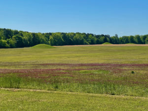
Pharr Mounds consists of eight Native American burial mounds in an area of about 100 football fields. We spotted four of the mounds, but the others must be hidden from view. They were quite scenic, yet our photos don’t capture how cool they look. Rats. Back at Donivan Slough, Amy decided to rest while I checked out a short trail, said to go past cool swampy areas. Today, the area was pretty dry, so not very impressive.
Heading Toward the Tenn-Tom Waterway
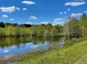
We shuttled a car up to the Tenn-Tom Waterway, one of our possible camping spots tonight, the other being Pharr Mounds, which features a bathroom and covered concrete patio. Tenn-Tom has a spot off the parkway with picnic tables and garbage cans – nice. We also walked down a blacktop path to the canal, which was pretty. The waterway, incidentally, is a whopping 234 miles (376.6 km) long and connects the Tennessee and Tombigbee Rivers. After drinking in the scenery, we hiked back to Pharr Mounds and the second car.
Our final day’s hike was an out-and-back, since there are no more interpretive pullouts for many miles. After that, Amy and I decided to drive the six miles (9.7 km) back to Pharr Mounds and camp there. While we prefer to camp as close to our daily ending points as possible, Pharr Mounds has a bathroom and sink, which helps with washing up. It’s also more scenic than the Tenn-Tom pullout. Finally, tonight is supposed to be cold, with overnight lows around 36 F. (2.2 C.). We’re trying an experiment to see if you’re warmer and drier by setting up a tent on concrete under a roof (me) versus tenting on the grass under the sky (Amy).
Disclosure: This post contains affiliate links (among regular links) to products I own and like, or which I think you might like. This means that, at no extra cost to you, I will earn a commission if you click through and make a purchase.
 I think at least my tent pad will stay dry on the concrete. I’m guessing my rain tarp will still have lots of condensation in the morning. We’ll see!
Weird Bugs
Oh! One more thing. Amy and I were just commenting on how we are so lucky to have had little issues with bugs. Tonight, these winged beetles (that’s what we think they are) began buzzing all over Pharr Mounds. So far they haven’t bothered us or our belongings, but they’re all around us. It’s a little creepy, since we don’t know what they are.
Snowshoe
Natchez Trace Miles Today: 20.6 (33.2 km)
NT Miles Overall: 300 (482.8 km)
NT Miles To Go: 144 (231.8 km)
A good book on the Natchez Trace is Nashville to New Orleans Road Trip, a Moon guide by Meg Littman that includes info on the Trace.
I love my Sea-to-Summit ultralight sleeping pad. Get yours here!


