Today’s hike was about 15 miles (24.1 km) from Norwich Road to Old Victoria, a small, restored mining village. This hike was one of my all-time faves so far on the North Country Trail. But before I say why, I’ll tell you how the day began.
I set my alarm for 5:30 a.m. to give me plenty of time to break camp, eat, get to Old Victoria and rearrange the car. It’s way more complicated than you’d think to backpack with a car. If you’re just backpacking, you have the same stuff, packed in the same place, day after day. But when you can access a car, there are times you can off-load items or bring extras to your campsite (if you camp near your car), such as a camp chair. So your car is packed with extra things, and it’s easy for items to get lost in the car if you chuck them there without thought after a long day on the trail. But I digress.
Heading Out from Norwich Road
It took forever to break camp and get going because the sun didn’t rise until just after 7 a.m. The parking area where I camped was wet and muddy, so I had to make a gazillion slow trips back and forth from my tent to the car. Oh, well.
Russ met me at Old Victoria and shuttled me right back to Norwich Road, almost like a “Groundhog Day” incident! A little before 9, I was off. I knew the day would feature a lot of climbs; I think I’m still in the Trap Hills. But boy, were there ever a lot of climbs!
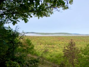
The positive was that I was rewarded with incredible, sweeping views of the mountains and Ottawa National Forest. Even though the morning was often cloudy, it didn’t dampen my enthusiasm. Most of the vistas were on great, rocky outcrops very reminiscent of the beautiful views and rugged terrain of the Superior Hiking Trail and Border Route Trail.
The Afternoon Has More Surprises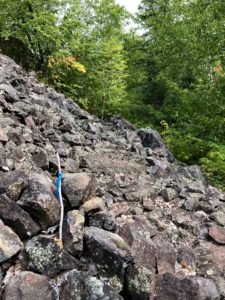
Somewhere in the afternoon, miles from Norwich Road, the trail rolled into dark woods, some with steep ravines and eroded areas that will likely need re-routes. The path became quite rocky and mossy. At one point, I noticed a steep, sloping hill to my left, totally comprised of white boulders. And then – oh no – the blazes pointed to the hill! Would I have to climb up using my hands?!
Turns out there was a path chipped into the side of this slope, so it wasn’t bad at all. In fact, it was enjoyable because it was so unique.
Shortly after that, I came upon a hiking party of nine. I was so entranced watching them, as they were sitting around on the path resting and eating snacks, that I didn’t realize I was on a narrow precipice. I could have taken quite a tumble! The 10 of us chatted a while. They had met through Boy Scouts and their vehicles were parked at Norwich Road, right where I had been. Ha!
Day Winds Down
After that, the trail rolled all around before leading me into the western end of Old VIctoria. I laughed when the trail took me right through an old stone structure. Yes, in the front door and out the back!
Old Victoria has a shelter with two wooden bunkbed sets, plus a small deck with a (broken) chair. I reached my car first and shuffled around gear (see opening graf!), then hiked to the shelter and dropped most of my stuff.
Then I continued hiking through the forest until the spot where the trail pops out onto Victoria Dam Road. From there, I hiked the shorter road walk back to my car, where I grabbed a few more things and headed to the shelter.
Shelter #2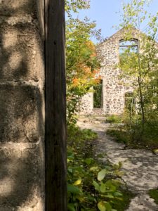
In all my hiking, I’ve only stayed at one other shelter. It was the Marengo Shelter on the NCT in Wisconsin. That one was an AT-type shelter, with three sides and an open front. The interior was bare except for some nails in the walls for hanging things and a broom. So this shelter seemed quite posh!
I set up my chair on the little deck and ate a great dinner of spaghetti and meat sauce, washed down with some beer. I have service here, so I was able to call home, download the local paper and catch up on emails and texts.
Interestingly, I heard a bunch of coyotes tonight. I haven’t heard them much on the NCT. I heard them a lot on the Arizona Trail and while in Big Bend National Park. Since then, I love falling asleep to their yips and howls.
Tomorrow’s hike will involve either swimming across some water due to a beaver dam (no!), bushwhacking around it or taking a detour. I keep hearing different stories as to what you need to/can do, so I’m a bit nervous. Wish me luck!
Snowshoe
MI NCT miles today: 14.7 (23.7 km)
MI NCT miles to date: 444.6 (715.5 km)
Total NCT miles to date: 1,212 (1,950.5 km)
Total NCT miles to go: 3,388 (5,452.5 km)


