Disclosure: This post contains affiliate links (among regular links) to products I own and like, or which I think you might like. This means that, at no extra cost to you, I will earn a commission if you click through and make a purchase.
Today’s goal was a trailhead near Alto, Mich., some 21 miles (33.8 km). I was pretty happy when I got up this morning. My tent was fairly dry, and I’d slept well. I broke camp pretty quickly, throwing out an old towel and blanket that had gotten super wet and dirty during last night’s deluge, but weren’t worth salvaging.
Then it was off to Buck and Jenny Hough’s home in Alto. The two are super trail angels. Buck led me to my ending point for the day, then shuttled me back to the Boy Scout Cabin to begin my hike.
Heading to Alto
The day was intimidating. I was facing a long hike in temperatures predicted to hit 90 F. (32.2 C.). The first mile or so (2 km) wound through Lowell, the headquarters of the NCT. It’s a pretty community, and there were swans in the Flat River. I took a quick (and short) detour to see the HQ, which features cool trail paintings on the side.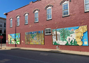
Although I’d hiked just a little over 1 mile (1.6 km) at this point, I was already pretty warm, thanks to wearing my bug suit pants. I’d started the day wearing them since the mosquitoes are suddenly terrible, and seem to be everywhere. But there were no skeeters in Lowell. And while these bug suit pants are light and airy, the tight mesh weave makes them hot. So thinking that my day was all road walking until the last mile or so, I took the bug suit pants off in Lowell.
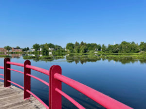
Of course, just after I took them off, the trail tricked me by going off-road, winding around the river. This area was thick with overgrown vegetation and FULL of mosquitoes. It was so awful, I jogged through it to get out of there ASAP. Luckily, it was just under 1 mile (1.6 km). When I popped out and crossed the adjacent bridge, I could see the old bridge in the distance. Buck says the NCT will one day cross the old bridge.
Loving the Roads
After that terrible experience, I was only too happy to hike along roads for the bulk of the day. Fortunately for me, many sections were shady. And even when I was under full sun, the lower humidity made it bearable.
At one point, some 14 miles (22.5 km) in, I saw there was an out-and-back segment that was about 1.5 miles (2.4 km) total. It’s marked on the Avenza map as official trail, yet it’s not counted in the mileage, which was confusing. Still, I figured I should do it to be official. My long day was about to get longer! Rats.
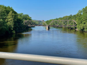
Silly me, I decided not to put on those bug pants, even though I saw the trail ran alongside the Thornapple River. It was just laziness; I didn’t want to keep putting them on and off. And I hoped maybe the mosquitoes wouldn’t be bad here. WRONG! They were awful, so I really couldn’t enjoy this stretch, which Buck would later tell me is a prime trout-fishing river.
Day Is Done
After that, I had mostly road walking until a final mile-plus (1.6 km) of trail. I put on my bug pants and bug head net, and it was fine.
Once I reached my car, I drove straight to the Houghs’ place in Alto. My goodness, they are trail angels extraordinaire! 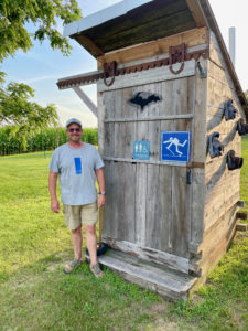 They have a spacious property and let hikers camp out back. Buck has built a hiker-themed outhouse for our use, plus has plugs for our electronic devices. His wife, Jenny, loves to cook for hikers.
So I pitched my tent, showered under a hose they have hooked up to emulate an outdoor shower, then ate a great chicken dinner Jenny had prepared. Can’t forget to mention sampling Buck’s homemade hard cider!
So Lucky
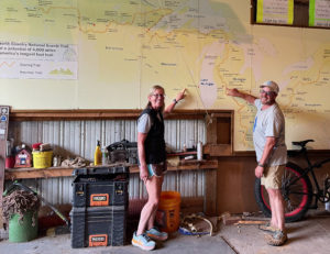
Buck showed me around the place, which is pretty incredible. He has a huge, original map of the NCT route, dating to the 1970s, which is displayed in his garage. (And, yes, Alto is marked on the map!) He’s also created these humorous whirligigs that are set out all around his yard.
I probably should hit the hay soon. Tomorrow is my last day (!) on the trail, at least for the time being. It’s been an amazing adventure, as always.
Snowshoe
NCT Miles Today: 22.4 (36.1 km)
MI NCT miles to date: 979.9 (1,577 km)
Total NCT miles to date: 1,728.9 (2,782.4 km)
Total NCT miles to go: 2,871.1 (4,620.6 km)
Looking for product recommendations? I love my Big Agnes Copper Spur tent, Coghlan’s Bug Suit Pants, and Benvo Head Net. I’m really impressed with how the tent stood up to that deluge, and how the bug gear kept the mosquitoes at bay.


