Today’s trek to the Route 30 shelter took everything I had. And then some. But first, last night. I slept quite well, in that I didn’t hear any mice or critters outside my tent or in the shelter. Phew!
In the morning, I packed up and was ready to hit the trail by 8 a.m. I knew I’d need a lot of time to get to the Route 30 shelter, as it was 22.5 miles (36.2 km) away. And on this terrain, that takes time.
Disclosure: This post contains affiliate links (among regular links) to products I own and like, or which I think you might like. This means that, at no extra cost to you, I will earn a commission if you click through and make a purchase.
Despite my daunting day, after just two hours on the road I took a quarter-mile (.4 km) detour to hit a market that a man from my campsite said had great “yuppie food.” Yum! I ordered a gourmet turkey BLT sandwich, plus bought some Gatorade and a chocolate candy bar.
Making My Way to the Route 30 Shelter
The trail was difficult, per usual. But then it segued onto a local ski hill, the Laurel Mountain Ski Resort. The guy from camp told me the signage wasn’t great here. And sure enough, the signs led me into the center of the ski runs, 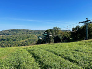 near the lifts, then stopped. I had no idea where to go. Luckily for me, some men were working on the ski lift and showed me the way.
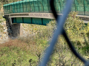
After the ski hill, the next fun bit was crossing over a highway on a bridge that was signed the Laurel Highlands Hiking Trail. There were some American flags on it, too. As I crossed, I raised my trekking poles triumphantly over my head, hoping someone driving below would give a celebratory beep. But no one did.
Busting My Butt
When I had about 8 miles (12.9 km) to go, the terrain flattened out a bit. It was still hilly, rocky and rooty, but no insane inclines. So I pushed as hard as I could, as I was racing to reach my campsite before dark.
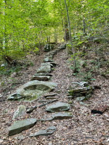
 It’s too bad, really, because this section was very interesting. There were some swampy portions, dense pine forests and these incredible areas featuring massive rocks (erratics?) that you wind in and around.
With just about 1 mile (1.6 km) to go, the trail then went straight uphill. Of course! I saw some larger, black animal streak across the terrain ahead of me. I couldn’t tell what it was, but it looked like a large cat or canine. Yikes! A cougar? Wolf?
Arriving at Camp
Got to camp just before darkness fell. I was the only one there, which was a little unnerving. There is supposed to be a major storm moving in tonight. I’m a tad nervous.
Snowshoe
Today’s Miles: 22.5 (36.2 km)
PHT Miles to Date: 757.6 (1,219.2 km)
PHT Miles to Go: =25 (40.2 km) *recalculating


