Today’s trek to West Union SP 20 was so layered! Bear with me here. I’ll explain throughout this entry.
So today’s trail angel, Pat Lewis, is a former AT hiker who loves to help fellow trekkers. He and his wife just opened a laundromat, even though they’re essentially retired. Anyway, Pat said he could shuttle me either early morning or early evening. I went for early evening, as I had to break camp today and it’s dark here until about 7 a.m. I didn’t want to have to do everything in the dark.
Disclosure: This post contains affiliate links (among regular links) to products I own and like, or which I think you might like. This means that, at no extra cost to you, I will earn a commission if you click through and make a purchase.
I awoke to the pitter-patter of rain on my tent. No! Luckily, it just sprinkled maybe 10 minutes, and everything dried out quickly. I had a leisurely breakfast, then broke camp and had time to gas up my car and buy some ice before parking my car at Lake Manor Restaurant and heading out. It was 10 a.m.
Making My Way to West Union SP 20
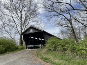
It was cloudy and cool for the first few hours, which was fine with me. I definitely prefer colder weather over hot, humid temps. Early on, I spied a covered bridge off to my right. I decided to check it out. There was a guard rail in front of it, so I snapped a few photos and headed back to the trail. Turns out I was supposed to hike through the bridge! I didn’t see any blazes directing me there, but fortunately the error didn’t require any additional miles.
Imagine my surprise about an hour later to stumble across ANOTHER covered bridge. This time, I did see blazes pointed 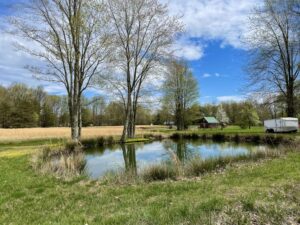 its way. It was around lunch time, so I ate my lunch inside the bridge. Before heading on, I checked the app and … I was NOT supposed to hike through this covered bridge! There was supposedly a trail just before the bridge that led under a busy highway. Hmm.
Backtracking, I saw no blazes, but there was an overgrown trail right before the bridge. There was also a downed guard rail in front of it, so maybe there was a blaze on the rail. Anyway, I followed this whisper of a trail under the highway, and then it totally disappeared and was all bramble. I bushwhacked my way back to the road/route.
More Challenges Ahead
So the trail here is trying to keep you off of busy Hwy. 68. But just after going under it on that barely-there trail, you hike a little on Hwy. 68, then are supposed to take a semi-circular road to the right to avoid more of the highway. There were no blazes here, and a sign said “Private drive.” Hmm. I went back and forth over whether to just hike more on the highway or take the private drive. I did the latter.
After emerging once again onto Hwy. 68, I saw no blazes, so headed east along the highway. Mistake. I was supposed to go straight. Argh. So more backtracking. Thankfully, there were no more mistakes after that.
Enjoying the Scenery
Up until now the scenery was pleasant, but nothing too exciting, not counting the very-cool covered bridges. But in the afternoon, things got quite scenic. The roads were often hilly and winding, but pretty. There were some beautiful reflections in small ponds.
I was also super impressed that when a few dogs aggressively ran and barked at me, their owners were right there, calling the dogs back and apologizing. Also, I stopped once for a break, sitting off the roadside eating a snack. Three different people stopped in their vehicles to see if I was OK. NICE!
Camping in a Cool Spot
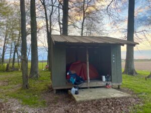
Pat picked me up at the The Home Place, a cool store about a half-mile (.8 km) off the trail, efficiently shuttling me back to my car. I then drove to Mike Vogel’s place. He’s also a former AT hiker who is paying it forward. Mike built a shelter on his property, plus a latrine, fire ring, picnic table and more. This is incredible! I am staying here two nights, so I set myself up pretty comfortably.
I’m only looking a day or two ahead at this point. I know I’ve got another day of road-walking tomorrow, and the weather should be nice. On Sunday, rain is coming at some point. I’ll also be in a motel that night, and can wash my stinky duds.
Snowshoe
NCT Miles Today: 17.7 (28.5 km)
Ohio NCT miles to date: 332.9 (535.8 km)
Total NCT miles to date: 2,286.4 (3,679.6 km)
Total NCT miles to go: 2,313.6 (3,723.4 km)


