I knew today’s trek to Delphos Stadium would be challenging in the opposite way as my hot and windy hike yesterday, as the forecast called for rain all day. ALL DAY. Ugh. But what else can you do but hike on?
Thankfully, my Tuesday shuttler, Emily, said she could also shuttle me today. Since I hiked farther than planned yesterday, today’s trek would be about two hours shorter. So I decided to head out late – 10 a.m. – to catch up on things and possibly hike the final hour in dry weather.
Disclosure: This post contains affiliate links (among regular links) to products I own and like, or which I think you might like. This means that, at no extra cost to you, I will earn a commission if you click through and make a purchase.
Heading to Delphos in the Rain
Emily and I met at Delphos Stadium. It was barely drizzling out. She’s done a bunch of the NCT so far, so we traded some stories of our experiences. Before long, I was back in Mandale and heading out.
I actually didn’t get too far, as a local stopped me almost immediately to see if I was hiking the trail. He said he’d grown up alongside 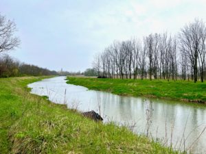 the canal and was fascinated with its history, and the trail. We had a nice chat before he drove off.
Upon checking my app (I didn’t see any blazes), I realized I’d taken one wrong turn yesterday. I shouldn’t have ended up at the Mandale church, but rather a path a half-block over. Oh, well. No biggie.
The route from here starts off on a small, gravel road paralleling the old canal. It eventually turns into a paved road. I made it 2 miles (1.6 km) in dry weather before it began to rain reasonably hard. I dug out my trusty umbrella and stayed pretty dry, with the exception of the back of my legs.
Slogging in the Rain Toward Delphos Stadium
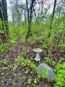
After about 5 miles (8.1 km), the trail ducks into the woods for a little over a mile (2 km). The vegetation here was a little overgrown, 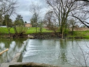 making for a narrow passage not conducive to an umbrella, so I put it away. The rain had dwindled anyway. There was a small bird bath in the woods – ha! – and an errant soccer ball.
Partway through, the trail unrolled out of the woods and onto a farm road paralleling the Little Auglaize River. You could see a church spire at nearby Ottoville in the distance; I’m sure the view would be quite pretty on a sunny day. A pair of geese and their goslings waddled into the water and began paddling away, but I couldn’t capture their photo in time.
An Error Entering Ottoville
This path along the river was difficult to navigate, as the farm road’s tire tracks were muddy and very slippery. But if you tried to walk on the adjacent grass, it was slanted and difficult. I thought I’d have to stay on this until Ottoville, but then the trail went back into the woods.
Here, the path became increasingly overgrown, with thorny vegetation blocking the way. After a few minutes I figured I was off track. I’d definitely seen blazes pointing me in here, but they were faded, so I figured there was a reroute and someone forgot to paint over them. As I was heading back to the river, I saw a trail paralleling the one I was on – and THAT was the real trail. I’m guessing there was a fork in the road that I missed, but I didn’t take the time to go back and investigate.
Ottoville and Beyond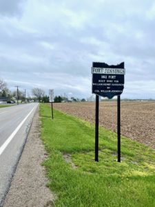
I had a pleasant stroll through Ottoville, after taking a lunch break near the river and some adjacent ponds. More rain was predicted from 1-3, but thankfully it only ended up being a few random showers on and off, with none too heavy.
After Ottoville, you hike through Fort Jennings, a town built on the site of – you guessed it – the former Fort Jennings, built for the War of 1812 at the instruction of President William Henry Harrison. I’m finding all of this history so fascinating, especially since a lot of it is coinciding with the history I learned last year thru-hiking the Natchez Trace and Potomac Heritage Trail.
Hangin’ in the Laundromat
The Microtel here in Delphos doesn’t have laundry facilities, so I’m at the local laundromat 2 miles (1.8 km) away. It’s a nice, clean one. I’ve got lots of wet, muddy and sweaty clothes to wash from the last few days.
I’ll be camping the next three nights, so I hope the campsites aren’t too muddy. It was definitely a good call not to camp last night. From the little I hiked in the woods today, I would have had an unpleasant time camping in the rain and mud, and then hiking through more of it today.
Snowshoe
NCT Miles Today: 16.3 (26.2 km)
Ohio NCT miles to date: 117.5 (189.1 km)
Total NCT miles to date: 2,056.3 (3,309.3 km)
Total NCT miles to go: 2,543.7 (4,093.7 km)
Today’s most valuable gear: My beloved hiking umbrella, rain pants and poncho.
If you’re in the area, I recommend staying at the Microtel.


