Today’s hike from Sunshine Ridge to Shawnee State Park was fun and pleasant, yet quite hard in many parts. But before I talk about the hike, let’s talk about my lodging.
Last night I camped at Shawnee State Park. Being as it’s the early part of the season, I was one of the only campers here. My site was unremarkable, and featured some gross, muddy mounds that I think could be ground hornet nests or something icky like that. They were inactive, thankfully. But the good part was that I was near what appeared to be a new bathroom, which was very clean and spacious. And I had it all to myself!
Disclosure: This post contains affiliate links (among regular links) to products I own and like, or which I think you might like. This means that, at no extra cost to you, I will earn a commission if you click through and make a purchase.
This morning, it was just 35 F. (1.7 C.). Brr! So I hauled my stove, coffee and breakfast into the (heated) bathroom and enjoyed it there, just like my friend Amy and I did on the Natchez Trace in the spring of 2021.
Heading to Shawnee State Park
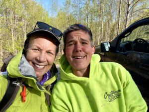
I met shuttler Nikki Allen at my ending point in Shawnee for a drop-off at my starting point. She is one of the section supervisors, and was super kind, informative and lively. Nikki mentioned something about The Hill in my future – some  crazy, steep incline that’s followed by a crazy, steep decline. Hmm.
Anyway, the first 4-5 miles (6.4-8 km) of my hike were on remote gravel roads. Luckily, no dogs were out. I passed two cemeteries, and both were FILLED with flowers on the graves (the photo doesn’t do it justice). I’ve never seen so many flowers in a cemetery before.
Then I entered Shawnee National Forest. The first few miles were generally pleasant, first featuring a wide path, then a narrow one chipped into a steep hillside. This latter portion had many downed trees, but it wasn’t too difficult to climb over them. It was after my lunch break that the “fun” began.
Is This “The Hill”?
After traversing the narrow path chipped into the hillside, the path widened again. But it pitched steeply uphill for quite a time. Then it tumbled downward in an equally steep pitch. I conquered “The Hill”! Except this pattern repeated itself for a  few hours. Super steep uphills followed by super steep downhills. Was this what Nikki was referencing or not?
While the hills continued, after that first two hours, the inclines/declines were a tad gentler. The last few miles were lovely, downhill switchbacks until I reached my car in Shawnee. While I was just minutes from my campsite, I had work to do.
Heading into Town
I immediately drove to Portsmouth, about 20 minutes away. This is a bigger town with a grocery store, where I stocked up on more sandwich fixings for my lunches, plus ice. While it was cold this morning, the temperature hit about 65 F. (18.3 C.) by the end of the day. And while the overnight low temps will still be quite chilly for the next few days, the highs will climb once again into the low 80s F. (27s C.).
I also needed to get to a spot with wifi and cell service. I’ve had sporadic service with both, and that’s a problem. Not because I’m into social media or 24/7 news coverage, but because I need to verify meeting spots with future shuttlers, plus use Google maps to figure out my routes to these spots. These days, no one has paper maps. So if you don’t have service and can’t pull up a map on your phone, much less a route, you’re screwed.
Oh – I did not see one other person on the trail today. I’m trying to think back on the last week to see how many people I encountered. I passed several people on the trail through East Fork State Park, and one guy on a subsequent road walk. But other than that, I’ve been out here all by myself.
Snowshoe
NCT Miles Today: 17.5 (28.2 km)
Ohio NCT miles to date: 401.4 (646 km)
Total NCT miles to date: 2,354.9 (3,789.8 km)
Total NCT miles to go: 2,245.1 (3,613.1 km)
