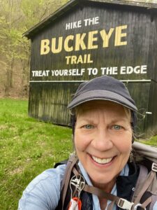
Today’s trek to the Sunshine Ridge Trailhead had been in peril, as my shuttler for today (and the next two days) had a family emergency and had to bail. I spent a ton of time yesterday trying to find a replacement for all three days, and achieved my goal around 10 p.m., in between doing laundry and settling in at my motel in Seaman. Phew!
Today, kind Mike Vogel drove an hour from home (with his wife, Marilyn, and their dog) to do the shuttle. The Sunshine Ridge Trailhead is quite remote. You really feel like you’re in Appalachia here, with all of the mountains/foothills and the extreme rural-ness. The Vogels got turned around en route, and when we got together for the shuttle, neither of us had cell service – another feature of this area’s remoteness.
Disclosure: This post contains affiliate links (among regular links) to products I own and like, or which I think you might like. This means that, at no extra cost to you, I will earn a commission if you click through and make a purchase.
Heading to Sunshine Ridge
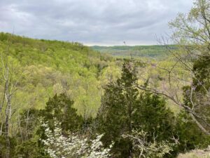
But we eventually got to my starting spot, and I started hiking around 9:40 a.m. After a hot week, today was cloudy and windy, with temperatures topping off at just 50 F. (10 C.). The first portion of this hike piggybacks on another trail that heads uphill to a pretty overlook. Then the BT/NCT continue to roll onward.
Once past the the overlook, the trail featured some downed trees, along with a gravesite. Nikki Allen – the section  supervisor (I hope I have the correct title) – w/ho will be shuttling me the next two days, asked me to make notations as to which areas needed maintenance. She said a crew had come in (last year?) and cleaned up her section very well, but the recent storms downed a ton of trees. She wasn’t kidding!
The trail here is very pretty, featuring a lot of rocks, rocky outcrops, streams and more. It’s hilly, but there are a lot of switchbacks that make the hike easier. But the storms definitely have taken their toll. There were many places where several huge trees were downed across the trail, and it always seems to be the spot where the trail took a 180-degree turn. So you’d get past the trees, then lose the trail.
Winding Down the Day
Several sections also had areas with numerous other trails. So you’d get past the downed trees and resume hiking on a trail, only to realize later that it wasn’t the BT/NCT.
 The last several miles of the trail had a lot of downed limbs and sticks. They weren’t big, so you’d think it wouldn’t be a big deal. But when there are so many sticks/branches on the trail, even if they’re slim, they make you slip and stumble, or give you good pokes. It wasn’t fun. In addition, many spots had leaf piles that were ankle deep, which was also surprisingly difficult.
A hike like today, while challenging and frustrating at times, is a good reminder of how hard our trail maintainers work, and how difficult their work is. Because Mother Nature always has something up her sleeve.
Tonight I’m camping at Shawnee State Park. There is a beautiful, new shower/washroom near my site, which also includes a laundry facility. This may be the nicest campground bathroom I’ve ever used.
Snowshoe
NCT Miles Today: 15.9 (25.6 km)
Ohio NCT miles to date: 383.9 (617.8 km)
Total NCT miles to date: 2,337.4 (3,761.7 km)
Total NCT miles to go: 2,262.6 (3,641.3 km)


