Today’s hike to the Foster trailhead required some pivoting. So, last night I booked an Uber shuttle from the Grandin Road trailhead back to Oregonia. But when I drove to the Grandin Road trailhead this morning for the shuttle, I found a ton of construction vehicles parked there. Apparently there’s a major road reconstruction project going on, and the trailhead is closed. I saw there was another trailhead just under 3 miles (4.8 km) south – Foster – so I decided to park there instead. Luckily, the Uber driver agreed.
Disclosure: This post contains affiliate links (among regular links) to products I own and like, or which I think you might like. This means that, at no extra cost to you, I will earn a commission if you click through and make a purchase.
So the Uber driver followed me to the Foster trailhead, where I dropped my car, then shuttled me back to Oregonia. I was on the trail by about 10 a.m. Late, for sure, especially since I was now going to hike nearly 18 miles (29 km) versus the 15.5 (25 km) I’d planned. But it really wasn’t a big deal. Since the trail is flat and on pavement, it would only mean an extra 45 minutes or so.
Striking Out for Foster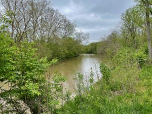
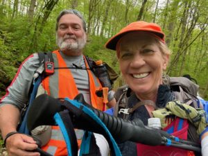
Today’s forecast was for cloudy weather, but moderate temps. Yes! My first several miles were quite enjoyable. There were so many cyclists out on the path, which was great. I like seeing trails in use! I stopped to chat with a woman who is training for an Ironman competition, plus even met a few hikers – something rare so far. One was a guy named Skyline, a local who took that trail name in honor of Cincinnati’s famous chili joint. He kept encouraging me to hike the PCT, which is on my list, of course. I also met AT Rock-Flipper (see photo below) who is hiking the entire Buckeye Trail, I believe.
Early in my hike, I passed a sign for Morgan’s Riverside Campground and Canoe. This company mainly runs canoe trips, but also has a campground where I’d booked a stay for tonight. I popped in to make sure everything was set for tonight (they’d just opened for the season), and the guy said the campground was a few miles farther down the path than the canoe operation. Eventually, I passed it. It looks nice!
Hike On!
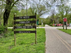
I’m continuing to identify plants with the help of the Seek app. Some of the ones seen today were trillium (I actually knew that one), garlic mustard (a huge, problematic invasive on the Ice Age Trail) and rough horsetail. I also enjoyed trekking across an old bridge and seeing many cool views of the Little Miami River. In one spot, there’s info about Fort Ancient, which is a historic Hopewell Native American site and National Historic Landmark that may become Ohio’s first World Heritage Site. It was off the trail, though, and I didn’t have time to tour it. Rats.
Tonight at Morgan’s the owner came out and gave me a better site – one that’s far from a noisy group of kids, plus close to the bathrooms and the river. Excellent!
Snowshoe
NCT Miles Today: 17.9 (28.8 km)
Ohio NCT miles to date: 265.5 (427.3 km)
Total NCT miles to date: 2,204.3 (3,547.5 km)
Total NCT miles to go: 2,395.7 (3,855.5 km)
Today’s most valuable gear: My Solomon trail gaiters, which kept the mud and moisture off my shoes, and my favorite Prana Halle hiking pants.
