Today’s goal was Mount Hope Cemetery. Well, not exactly. It was a parking area and campsite across the road from Mount Hope. When I woke up this morning, it was about 28 F (-2.2 C) and my car was covered in frost. The forecast was for a high of about 40 F (4.4 C) with rain beginning about 5 p.m. and lasting much of the night.
I’d hoped to camp at my ending point, but took Trail Angel Syd’s offer of bunking at her home instead. We met at the parking area and decided to check out the campsite first. It was maybe .3 miles (.5 km) from the parking lot, and when we were almost there we reached an impasse. A portion of the St. Joseph River branched off and cut through our route. There was no bridge here or evidence of one. Instead, the trail sloped down to the water, which was knee-deep and rushing. Hmm. I’d have to come across here at the end of the day. Perhaps I could find another way around it.
Disclosure: This post contains affiliate links (among regular links) to products I own and like, or which I think you might like. This means that, at no extra cost to you, I will earn a commission if you click through and make a purchase.
Destination: Mount Hope Cemetery
Syd shuttled me back to my starting point south of Albion, and I was off around 9:30 a.m. It was cool out, but not too much wind, so it wasn’t bad at all. Much of today was a road walk. The first stretch was nice and quiet. There were some reasonably steep hills. I saw the largest flock of turkeys I’ve ever seen 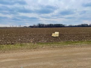 – about two dozen – and was able to enjoy a snack by the river near one bridge.
Shortly before lunch, I passed through the town of Homer, partly on a pleasant recreational trail. As I was leaving town, I found a nice spot to get off the road for lunch. Then it was more road-walking. The path continued to be undulating.
At one point, I was thinking about how I hadn’t seen one farm dog yet, one of the more unpleasant parts of hiking. And then … I had two in a row! The first was a little unnerving, as its owners weren’t around and it followed me a bit. The second dog’s owners were right there and called the dog back.
Day Is Done
Near the end of the day, I spotted a vast farm field with a plush chair sitting in the middle of it. Ha! A respite for hikers, perhaps? Oh, and everyone is harvesting sap for maple syrup right now.
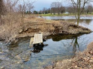
As you’re leaving Litchfield, the route goes through Fireman’s Park and onto real trail. This led me to the campsite I’d hoped to be at tonight – a sweet spot with nine tent pads created by some Boy Scouts, plus a picnic table and fire ring. I’d seen one spot earlier where I could have tried crossing the water on a downed log, but the water was pretty deep there (maybe waist high) and I didn’t want to chance it. So I waded through that spot Syd and I saw this morning. It wasn’t bad.
Now I’m tucked into Syd’s warm home, watching the rain fall. It’s supposed to change into snow tonight. This has been quite the interesting hike. Then again, they all are!
Snowshoe
NCT Miles Today: 20.4 (32.8 km)
MI NCT miles to date: 1,095.4 (1,762.9 km)
Total NCT miles to date: 1,902.6 (3,061.9 km)
Total NCT miles to go: 2,697.4 (4,341.1 km)


