Today’s trek to the ORV lot was an interesting one. And it was another day of changing plans. But you have to be flexible and patient when hiking, because things always come up.
My original plan had been to camp at Pinney Bridge last night, as I wrote yesterday. But with rain in the forecast, I booked a cabin at a campground in Kalkaska.That was a wise move. I’d hoped the rain would just be overnight, or maybe lingering in the morning. Nope. The forecast called for rain all last night, all day today, all night tonight and then finally tapering off tomorrow morning. Rats.
So seeing that forecast this morning, I again pivoted and booked this cabin for a second night. Tonight, I’d planned to camp somewhere near a place called Mac Neil Pond, which is about a mile (1.6 km) south of the ORV lot.
Heading Back to the ORV Lot
This morning, a wonderful trail angel named Ellen Whitehead met me at the ORV parking lot and shuttled me back to Pinney Bridge. Ellen’s son is a man named IB TAT, who is a long-distance hiker with a popular You Tube channel. I hadn’t heard of him, but I’m definitely checking it out!
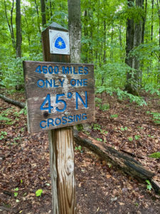
I hiked about 30 minutes under a light drizzle. The terrain was gently undulating with a few steeper hills. And then it started coming down pretty heavily. Unfortunately, this was when I hit the 45th parallel north, the only spot on the entire +4,600-mile (7,403 km) where the trail crosses it, so my pix of this spot aren’t so hot. I also had poor views at this section’s famous Landslide Lookout.
Rain, Rain, Go Away
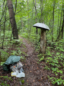
Despite wearing a raincoat and rain pants, I was getting soaked, mainly my legs. So I broke out my hiking umbrella. It really helps keep the water off your upper legs, plus your backpack.  Because even with a rain cover, your backpack will get soaked if you’re hiking hours in the rain.
Around 12:30, the rain stopped. Excellent! Just in time for lunch. The rain actually stayed at bay for most of the afternoon, There were sprinkles here and there, but nothing like the morning’s soaking. That being said, there was one stretch of trail near Sand Lake that was quite overgrown, with knee-high grass and ferns up to my waist and shoulders. All of that vegetation was wet, and so my lower half got soaked once again.
Interesting Tidbits
Oh, I should mention that today’s hike featured a lot of trekking along sandy roads. It was generally easy going. I also heard some weird, rhythmic noise about a mile north of the ORV parking lot. First I thought it was the bass beat to some music, and that there must be a festival going on. As I got closer, it sounded like machinery. Then I smelled gas/oil. I spotted a few buildings where the noise was coming from, but couldn’t figure out what it was. Ellen says it’s a natural gas/oil well station, and that there are a lot of these in this area.
I should also note that Sand Lake was very high! The beach was wiped out and lots of trees were under water. Ellen says all the lakes around here are high, and that last year Sand Lake was 2 feet (,6 m) above its normal level, a record high. Yikes! It’s actually gone down this year. It also used to have 30 feet (9.1 m) of beach. Dang global warming!
P.S. Good call on the cabin. It’s 7:30 p.m. and pouring out. Plus, there was really no place to pitch a tent today. Too much vegetation in the understory.
Snowshoe
MI NCT miles today: 16.5 (26.6 km)
MI NCT miles to date: 645.8 (1,039.3 km)
Total NCT miles to date: 1,413.3 (2,274.5 km)
Total NCT miles to go: 3,186,7 (5,128.5 km)

