Today’s hike was a 20.1-miler (32.4 km), from Wilderness State Park to a pine plantation at the end of a long road walk. I’d slept reasonably well last night, even though campgrounds are loud and somehow a timer went off on my phone at 1:30 a.m.! (I’ve never set a timer on my phone, so how that happened, I have no idea.) Anyway, shortly before 8, I was off.
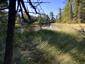
The first 5 or 6 miles (8-10 km) south of the park were wonderful – gently rolling terrain covered with softy, cushy pine needles or green moss. During this time, I stopped to take in a view of a body of water with a sign that identified it as Mona Lake, then pushed on. When it was time for my two-hour snack break, I found myself back at … Mona Lake. WHAT?!
Somehow I must have come across a spot where the path looped or something, and I got on the route going back north. Rats! That meant an hour lost and extra miles on my feet. But what can you do except hike on?
Leaving Wilderness State Park
I held my Avenza map app out for the next few miles to make sure I didn’t repeat my error. Luckily, I didn’t. However, I couldn’t find the spot where I erred. I think now I must have segued off the trail by following old blazes, because during my first foray, I crossed a dilapidated boardwalk while following these blazes. But on my second trip, there was no boardwalk.
Near the park’s southern end, the trail passed right near Lake Michigan. Specifically, Sturgeon Bay. I had to stop for a look. I 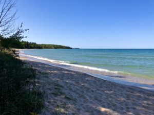 LOVE Lake Michigan, as I grew up seven blocks from her shores in Sheboygan, Wis. So it was fun to view her northeastern side.
The final stretch through Wilderness State Park was quite hilly. The NCT’s Harbor Springs Chapter maintains this area and had a brochure on dune swales, which is what I think it was. I was glad to finish that one!
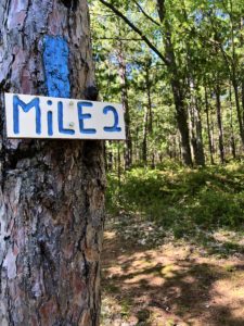
Fortunately for my quads, the next stretch was just lovely. It was another one of those gently rolling ones near scenic Wycamp Lake. This Harbor Springs Chapter marks each mile in its defined segments, which is helpful. The signs are also a big decorative, which I appreciate. Oh, and Chapter members also stashed water in a few spots where there was a long stretch without it, just like trail angels did on the AZT. Nice!
Winding Down
The last part of the day was a road walk of about 7 miles (11.3 km). I thought it would be easy, but it was mostly uphill and difficult. My feet were so sore. At the end of the road walk, the trail resumes in a pine plantation. Pines mean cushy ground and little undergrowth, so I decided to set up camp here, even though the ground was hummocky. I found one small flat space just big enough for my tent.
As I was setting up, I saw a text from trail angel Shari Sanderson, who offered to move my car tonight or tomorrow morning so I didn’t have to take a taxi. Twenty minutes later, after a speedy wash-up, I got in her car and we picked up mine in Mackinaw City. It’s now at a trailhead at the start of another road walk tomorrow; she’ll shuttle me once more. What a sweetheart!
I don’t think it will be so cold tonight. Yay!
Snowshoe
MI NCT miles today: 20.1 (32.4 km)
MI NCT miles to date: 552.2 (888.8 km)
Total NCT miles to date: 1,319.7 (2,123.9 km)
Total NCT miles to go: 3,280.3 (5,279.1 km)
Disclosure: This post contains affiliate links (among regular links) to products I own and like, or which I think you might like. This means that, at no extra cost to you, I will earn a commission if you click through and make a purchase.
Whenever I’m hiking on hilly terrain, I always carry The Stick with me, a body massager. It’s great to use on your quads and calves at night. Get yours here.
