Today’s goal was a lofty one: some 23 miles (37 km) from my Little Carp River campsite to Black River Harbor. But I felt pretty good about it. The trail through the Porkies should continue to be great, and there was some kind of road walk (snowmobile trail?) for a few miles near the end.
I hit the trail by 7:20 a.m. to give myself plenty of time. I’m glad I had no idea what was in store: another disastrous day on the trail.
I started off and immediately went the wrong way. Here in the Porkies, coming in from the east, the trail passed the first few campsites directly. Thus, I assumed I’d continue past our campsite. Nope. The trail was back at the entrance to the camping area.
Finally Heading to Black River Harbor
After that snafu, which only set me back about 5 minutes, I was off. The trail was lovely, as I’d assumed. It was another steamy day, so I paced myself. Wild thimbleberries were taking over the trail in a few spots. While they’re not quite in season, I was able to nibble on more than a few. Thimbleberries, by the way, are native to just a small portion of the U.P.
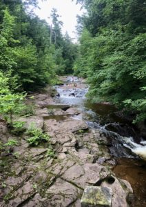
There was a river crossing early on, but I was able to scramble across on rocks. I impressed myself! A second crossing not too long after that was too deep and too wide to risk hopping on rocks, so I took the time to take off my shoes and switch to my water shoes. I didn’t want wet feet so early in the day. I made sure at every water stop to refill my bottles and filter water. With all of this heat and humidity, I’d need a lot of water today.
The Trail Devolves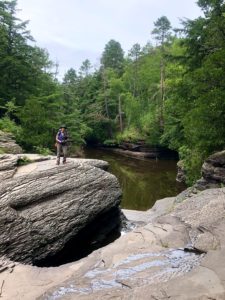
The NCT here heads west to Lake Superior, then plunges south. Once at Lake Superior, the trail markings were confusing and I ended up on the Lake Superior Trail and needed to backtrack. Rats. You don’t want to do a lot of backtracking on a long day..
Once across a creek feeding into Lake Superior, the trail heads southwest. Another snafu. A couple was coming out of a trail, so I went in, assuming it was the NCT. It led to a campsite and I got confused, then ended up scrambling up a steep embankment to the real trail on top. More precious time and energy wasted.
At this point, the trail devolved into a wet, muddy mess. I slogged through several miles of this, and even stopped to wring out my shirt and shorts for the second time, as they were both soaking with sweat.
I ran into one couple who were out trail running, but after passing me and seeing how bad the mud was, they turned around.
Presque Isle: A Highlight
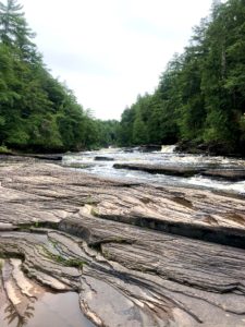
The best part of the day was coming upon Presque Isle, a super-cool series of waterfalls on ancient rocky outcrops. A couple took pix of me and offered to drive me somewhere. I’d have loved to have accepted, but of course I had to soldier on.
Another error: After crossing the water and starting up an enormous staircase, I double-checked the path. Yep, up the stairs. Once up top and heading down the trail, the markers disappeared. The correct path was to turn left partway up the staircase, but this turn wasn’t marked. Rats.
Once on the right path, I found the trail through the park lovely, and I enjoyed the breeze from the water. But once through the park, I still had 11 miles (17.7 km) to Black River Harbor. And I had developed a lot of chafing spots due to hiking in soaking duds, even though at one point I’d changed into yesterday’s damp pants and shirt, which were much drier than my soaked shirt and shorts.
The Start of the Disasters
The trail heading out of the park led me along dangerously eroded cliffs. I moved inland for safety, and there were more blazes here. What the heck? A re-route, no doubt, but a poorly marked one. The markings continued to be confusing, a jumble of old and new, and kept pushing me to the eroded cliffs. Forget this! I knew this path paralleled a road, so I bushwhacked my way onto it. I’d hike along the road to the final stretch of trail.
A few miles later, tired and hot, I stopped to filter water and discovered my water filter bag, which held my water filter, first aid kit and a few other important things, had detached from my backpack. It had to have been in that crazy section by the cliffs.
Although I did have back-up water purification tablets, they need time to work. And I was parched. So I flagged down a car and the wonderful family gave me two bottles of water.
The Final Disaster
With water in hand and the tablets purifying the river water in my Smart Water bottles, I headed into the final stretch: some six miles (10 km) of a service road to Black River Harbor. I thought I’d have it made. But almost immediately, the trail began sporting waist-high weeds, no markings and regular steep, muddy ravines with no safe way to get up or down. After tackling one and seeing how dangerous it was, I decided to bail. This was ridiculous!
Back on the road, I hailed a passing car, which happened to be driven by a DNR employee. The good news is that she took me back to Presque Isle and radioed a park ranger to help me. The bad news is that Black River Harbor is about 45 minutes by car. The DNR people couldn’t take me, there is no reliable taxi or shuttle service here, and there was no one I could ask for a ride, as everyone coming into the park had a reservation to camp here.
The kind employee, Steve, had no cell service and had to radio to a ranger in the east side of the park, where there was service, to call my few contacts to see if someone could drive me to Black River Harbor. Nope.
Day Is Done
After spending probably 30 minutes trying various options, Steve said I could camp in his ranger campsite here in Presque Isle. In the morning, a colleague, Tom Nemacheck, who was going to shuttle me back to my car at the end of the day, will pick me up and take me to Black River Harbor to resume my hike.
Oh, Steve also said that 6.5-mile stretch of trail is always bad. One year, a woman riding a horse and guiding a burro with her supplies tried to go down it, and the animals refused!
Since I’d lost my medical kit, Steve gave me some medical supplies he had. I asked a couple my age camping nearby if they had any soap to spare, and they did, so I’m reasonably clean tonight. Yes!
Clearly, this is not the day I intended to have. But you get what you get on the trail.
Final Words
Although I need to hike most seasons if I’m to achieve my goal of hiking all 11 National Scenic Trails before I die, I think I’m skipping summer. I HATE being hot and sweaty, and if you can get such hot, humid weather in the U.P. – where it’s normally in the 70s F. (20s C.) – then forget it. Abrasions are no fun, either, and dehydration is a huge risk.
Snowshoe
MI NCT miles today: 23.3 (37.5 km)
MI NCT miles to date: 378.9 (609.8 km)
Total NCT miles to date: 1,142.1 (1,838 km)
Total NCT miles to go: 3,457.9 (5,565 km)
Disclosure: This entry contains affiliate links (among regular links) to products I own and like, or which I think you might like. This means that, at no extra cost to you, I will earn a commission if you click through and make a purchase.
