
Today’s itinerary called for a 17-miler (27.4 km) from the western gate of McCormick Wilderness to our cars at Silver Lake Basin. We first had the .8-mile (1.3 km) hike down from our lovely campsite to the car. Easy!
Next we had a 90-minute shuttle to McCormick Wilderness. En route, we picked up more water and some sandwiches and treats for lunch on the trail. It was another sunny, lovely day.
I was a little nervous about hiking in a “wilderness,” because they often have different rules re: maintenance (not too much), blazing (none), etc. But the long road in was paved and the trailhead contained a pit toilet, so I was feeling better about things.
Striking Out for Silver Lake Basin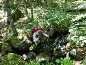
Amy started us off. The four of us decided to swap out the lead hiking position every 20 minutes as a way to pass the time. Also, it’s difficult to always be “on” as leader, watching for blazes and such. Well, Amy immediately took the wrong path, as the NCT isn’t blazed in the wilderness area. Luckily, she caught it right away.
The first stretch in the McCormick Wilderness was pretty, but very hilly. There were no blazes here, which is common for wilderness areas, or portions of trail that run through parks run by state or federal governments. Luckily, there were cairns to help us navigate. However, the dappled woods made the gray-brown rocks hard to see at times.
From Here, Disaster
We thought nothing could be worse than last Monday’s foray through swamp, then blow-down areas and then that huge flooded zone near the end. But today was horrible. Much of the McCormick Wilderness and the land beyond had been devastated by a storm from the previous fall, we’d later learn at camp from a local passing by in an ATV. It was all downed trees and bramble to scramble over, and easy to lose the way, even when the blazes resumed after the wilderness area.
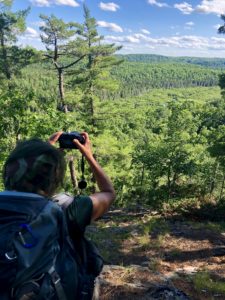
In one spot, there was a loop trail leading us to the day’s one pretty vista. But this wasn’t marked on the map, so we ended up walking in a circle and had to go back. Not fun when you’re moving so slowly and anxious to get back before dark.
So yes, we were moving often at less than one mile per hour (1.6 kph). In addition, it was quite humid and Ed and I blew through all of our water with a few hours of hiking left. No problem, I thought. We’ll just filter.
So I hauled out my filter, which I’d cleaned after my last hike, only to find it wasn’t working. Water was dripping out instead of streaming out. We couldn’t figure out the problem, so pressed on.
Finally at Silver Lake Basin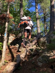
Although the four of us had split up at times near the end, we ended up picking our way through darkening woods together. It was about 9:50 p.m. when we finally got to our cars. Thank goodness there was enough light left to set up our tents and wash up.
We dined in the dark and went to bed, exhausted, without even speaking to one another.
Luckily, the bugs weren’t too bad all day if you used bug spray.
Snowshoe
MI NCT miles today: 17.2 (27.7 km)
MI NCT miles to date: 301.9 (485.9 km)
Total NCT miles to date: 1,065.1 (1,714.1 km)
Total NCT miles to go: 3,534.9 (5,688.9 km)
Disclosure: This entry contains affiliate links (among regular links) to products I own and like, or which I think you might like. This means that, at no extra cost to you, I will earn a commission if you click through and make a purchase.
