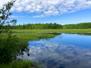
Today we thought we had an easy 16.1 miles (25.9 km) to our cars at the Rock River Falls parking area. Or should I say, we thought we had an easy day because we were only hiking 16.1 miles (km). So we decided to sleep in a little at our motel, the lovely Holiday Inn Express.
There was no sense striking out early, because we’d already scoped out the Rock River Falls area. There were no good camping spots (the land was too rocky, rooty and full of underbrush), so we’d planned on camping at the trailhead. A no-no, we know. But sometimes you have to do it if there aren’t any suitable spots to pitch a tent. Anyway, why get to a parking lot on a gravel road and set up camp early? We’d prefer to arrive more like 7 p.m. and limit our time there.
With that in mind, we confidently headed out at 10:15 a.m. from Jeske Flooding. Little did we know what was in store for us – possibly my worst trail day ever.
Heading Toward Rock River Falls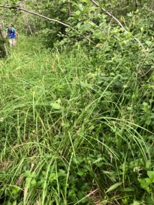
We departed Jeske Flooding and immediately walked into a severely overgrown marshy area. The mosquitoes were moderately annoying and we had to maneuver around a lot of mud and water, not to mention vegetation up to our shoulders. Luckily, it wasn’t a long stretch.
After a short road walk, we headed into the woods. The terrain was rather difficult, with these mogul-type mounds of earth, plus lots of rocks and roots. We were hiking blaze-to-blaze, which always takes longer. At one point, there was a re-route that was difficult to navigate because what we were seeing versus what was on our paper map versus what was on our Avenza map versus notes I’d copied from the local NCT chapter were all conflicting.
Eventually, we figured out where to go at Sigan Road and left that section behind. But we were horrified to see we’d only covered 3.5 miles (5.6 km) in two-and-a-half hours. Well, we’d make up time in the next section. HA!
Battling the Trees
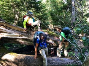
I’m not sure what the story is for the next chunk of trail (Sigan Road to approximately Rumely Road). Storms may have downed a gazillion trees and/or maybe there’s logging going on, but the terrain was horrendous. Again, we were hiking blaze- to-blaze, but now the earth was littered with downed trees, limbs, etc. There was no way to move quickly here. Rock River Falls seemed a lifetime away.
At one point, the trail went through Laughing Whitefish Falls State Park. It was filled with downed trees and didn’t look remotely scenic, as billed. There were a bunch of staircases here, which you’d think would have helped. But we all found climbing the stairs painful on the legs.
Eventually, we hit a service road and cheered. Surely, surely, we could make up time here. By now, it looked like we might roll into camp at 8 or 9 p.m. Maybe even 10. We were nervous.
But this service road had a gazillion downed trees blocking it, too. By now, the mosquitoes were getting pretty bad, so that didn’t help.
Victory in Sight
Once off this service road – where there supposedly was a parking area we never found – we went back into the woods. But the going was rough again. More moguls, more mud, more mosquitoes. Would we ever reach the Rock River Falls trailhead?
Then, the coup d’état. With about a half-mile (1 km) to go, we reached what was labeled a parking area on the map. But it was a creek that ran into a marsh. Some arrows point you into the woods, as if there is a re-route. But after following the marked path for just a few minutes, the markings disappear and the path ends. What to do? It was almost 9 p.m. This seemed like a cruel joke.
Thankfully, we found a spot where the marsh flowed into the creek and the water narrowed. I walked across on a beaver dam, while the others hopped to the other side of the water on rocks. So now we were on the other side of the water, but we had to bushwhack our way along the water’s edge and back to where the path picked up on the other side.
I know trail maintainers haven’t been able to get out this year due to the pandemic, and I totally get that. But I’d have preferred a road walk around the area with the downed trees, and I totally don’t understand that last section with the water.
At Camp!
We gave ourselves air high-fives (staying socially distant) when we reached the trailhead, then quickly set up camp as the sun set. Hopefully, tomorrow will be a better day. Rain is in the forecast near day’s end, but a lot of the mileage is a road walk.
Snowshoe
MI NCT miles today: 16.1 (25.9 km)
MI NCT miles to date: 227.8 (366.6 km)
Total NCT miles to date: 991 (1,594.9 km)
Total NCT miles to go: 3,609 (5,808.1 km)
Disclosure: This entry contains affiliate links (among regular links) to products I own and like, or which I think you might like. This means that, at no extra cost to you, I will earn a commission if you click through and make a purchase.


