Today’s destination: Mosquito River. This shuttle system is always a bit disconcerting, since we’re leapfrogging our cars west, but hiking east every day. So yesterday’s starting point is today’s destination. That’s just how it works!
So Ed and I got up early and struck out for the trailhead, and our car, around 7:15. We weren’t sure how many miles/kilometers it was to the trailhead, nor the exact way to go, since there are loads of trails that run around Beaver Lake, which sits in between Lake Superior and the NCT and the trailhead parking area. Our hike down ended up taking us 90 minutes, much longer than we’d hoped. Oh well, what can you do?
Once at my car, we drove it to the Valley Spur trailhead, which turned out to be the site of a really great cross-country ski and snowshoe place we’d visited in the past. We had several miles/kilometers of hiking in here that were nothing special. The trail wound through mostly scruffy vegetation – it was much prettier in winter!
Next up were several miles/kilometers into and through Munising. Now, the weather turned windy and cool, which was great because it meant no bugs!
Making Our Way to Mosquito River
Once through town, the NCT becomes a trail once again behind the Visitor Center, where there’s also a trail to Munising Falls. Ed and I saw the falls once in the winter, and the clock was ticking, so we soldiered on. We didn’t want to have another late arrival into camp. We’d already done that last night. Plus, we were hoping for an early night because tonight we’re meeting friends Amy and Bruce Eckert at Potato Patch campsite. And it’s Bruce’ s birthday today!
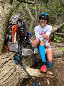
The scenery through this stretch of trail was pretty, and the trail was nice and dry. Until we neared Miner’s Beach, that is. Then we had to cross a lot of muddy areas. We had to keep walking on logs and rocks and veering back and forth to keep our feet relatively dry. It wasn’t so great, and we lost a lot of time.
Miner’s Beach
We reached Miner’s Beach, which is a popular spot with several overlooks. We snapped a few quick photos and continued on. At one point we had to walk a fair distance in sand, which was difficult. And it slowed us once again. But we were almost at Potato Patch, and I was excited at the idea of ditching a lot of my stuff there, then hiking the last few miles to Mosquito River, picking up our car and driving back.
So, the trail map shows a parking area right near the campsite. We passed through the parking area, then headed up an insanely steep, rocky trail. But where was the campsite? We walked almost to the top of this hill, when our GPS Avenza map showed we had passed the campsite. Yet we didn’t see anything. So we walked back down, assuming it was closer to the parking lot. Nope. We weren’t sure what to do, and there was no cell service so we couldn’t call the Eckerts to see where it was.
I was starting to panic, because we still had three miles (5 km) to Mosquito River, plus 1.9 miles (3 km) from the NCT to the parking lot on a spur trail. That’s two more hours of hiking. Plus, the gravel road leading from the trailhead to the main road is full of potholes and you have to drive super slowly. Time was running out!
Suddenly, the Eckerts appeared. The Potato Patch campsite was at the top of that rocky hill, they said, so we’d stopped just shy of finding it. Ed was beat, so he stayed back with them while I hiked on to finish the trail and drive our car back here.
Tackling the Hill Again
Once again, I scrambled up that darn hill. After that, the path was wonderful all the way to Mosquito River. No bugs, no mud, no big hills. The access trail down to the parking lot was a little dryer than yesterday, so that helped, too.
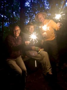
I finally returned to the parking lot near Potato Patch at nearly 8 p.m. Ugh. The Eckerts had waited for me to arrive before dining, so I quickly pitched the tent, washed up and we all had a lovely meal. I’d brought along veggies and dip, cheese and cashews, plus wine. So we had that, plus our freeze-dried meals. I also had sparklers left from the Fourth, so we lit those and sang Happy Birthday to Bruce.
It was a hard day, but I saw beautiful scenery and it ended well.
Snowshoe
MI NCT miles today: 19.5 (31.4 km) Doesn’t include access trail.
MI NCT miles to date: 193.6 (311.6 km)
Total NCT miles to date: 956.8 (1,539.8 km)
Total NCT miles to go: 3,643.2 (5,863.2 km)
Disclosure: This entry contains affiliate links (among regular links) to products I own and like, or which I think you might like. This means that, at no extra cost to you, I will earn a commission if you click through and make a purchase.
