Today I resumed my section-hike of the NCT, starting at the U.P.’s Mosquito River trailhead and heading to Beaver Creek. Ed and I drove up today, arriving in the area around 3:30, later than we’d hoped. We’ve got two cars and will be employing the two-car shuttle system, where we keep moving west, but hiking east.
To back up, my very first steps of the North Country Trail came here in the U.P., in Pictured Rocks. This was 2017. I knocked off the eastern half of the U.P., and since then I’ve hiked all of the Wisconsin miles and the Superior HIking Trail and Border Route Trail in Minnesota, all part of the NCT. Doing the western half of the U.P. will mean another 350 miles (563 km) crossed off. Yay!
Striking Out for Beaver Creek
A huge storm came through the Pictured Rocks area this morning, and we were glad to miss it. After driving some five to six hours from our home, we arrived mid-afternoon and dropped my car at the Beaver Lake trailhead. Then we drove Ed’s car to Mosquito Creek and took off.
The spur trail from the parking lot to the NCT was longer than I estimated from the map (1.9 miles / 3 km). But much worse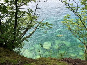 was the fact that it was super muddy and wet. It took us forever to reach the trail. In fact, we didn’t hit the NCT until 4:25 p.m.
I thought we’d make good time knocking off the next eight miles (13 km), as much of the trail here is atop the bluffs lining the Lake Superior shore, and relatively flat. We felt like we were hiking at a decent pace, but we were barely making 2.5 mph (4 kph). Soon it was clear we wouldn’t get to our campsite until at least 9 p.m. The only bright spot was that it stays light out longer up here.
A Little Problem
Then, a snafu. Why are there always snafus?! We reached the Coves Campsite, which is a few miles/kilometers due north of the Beaver Lake trailhead where my car is parked. I thought I’d booked a campsite halfway in between the NCT and the trailhead, but I’d actually booked a site at Beaver Creek, which is farther east on the NCT.
So we re-hiked a few miles we’d already completed a few years ago – 1.6 miles / 2.6 km to be exact. And now we’re farther away from the trailhead for tomorrow’s hike down to the car.
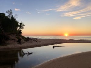
One positive: We reached our Beaver Creek campsite around 9 p.m., just as the sun was setting. It was beautiful, and made up for the long day.
COVID Hiking
Thanks to COVID and the popularity of PIctured Rocks, the trails were super crowded. I pulled on a mask every time we passed people, which was often. No one else had one. But I don’t want to take chances, since cases are soaring nationwide.
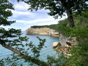
Re: the trail, it was relatively easy, and the lakeshore views were phenomenal. My one regret is that when we reached Chapel Rock, we didn’t get to see it in its full glory. Chapel Rock is this really cool rock formation with a tree growing right out of the top. I asked a hiker where the access path was, and she pointed me down the NCT. But once we got to the site, I quickly realized to get the best view, you needed to take a side trail down to the lake. The light was just perfect for gorgeous views, and we could have gone back. But I was so frazzled about our late start and slow pace that I had us push on. I do regret that.
Despite all of these mishaps, one amazing thing is that we had almost NO BUGS all day and night. That’s crazy! Everyone on the NCT Facebook hiking pages have been posting about how the black flies along the lake are horrendous, and now the mosquitoes are getting bad. I don’t know if the rain temporarily blew them away or what, but I’m not questioning or complaining. I’m so grateful!
Until tomorrow.
Snowshoe
MI NCT miles today: 8.4 (13.5 km) Doesn’t include access trail or repeated mileage.
MI NCT miles to date: 174.1 (280.2 km)
Total NCT miles to date: 937.3 (1,508.4 km)
Total NCT miles to go: 3,662.7 (5,894.5 km)
Disclosure: This entry contains affiliate links (among regular links) to products I own and like, or which I think you might like. This means that, at no extra cost to you, I will earn a commission if you click through and make a purchase.


