Today’s hike from Gooseberry Falls to Split Rock River was supposed to be a sunny one. Instead, shortly after we woke up it started to rain. Well, shoot! My phone said the rain would last until 9 or 10 a.m. Our clothes and gear were already full of mud, and this was making things much worse. We didn’t want to start the day off getting soaked, so we bided our time.
Disclosure: This post may contain affiliate links (among regular links) to products I own and like, or which I think you might like. This means that, at no extra cost to you, I will earn a commission if you click through and make a purchase.
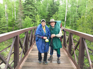
Ed, the champ, got out of the tent and made us coffee. I huddled inside and packed up our pads, sleeping quilts and everything I could. Finally, we could wait no longer and struck out around 9:30 a.m. Luckily, the rain stopped shortly after. But it was cool and windy. We didn’t want to risk hypothermia again, and were fed up with the mud and rain, so we decided to bag our last night’s camping and booked a room at the AmericInn in Silver Bay. That made the day easier to take!
Heading Out from Gooseberry Falls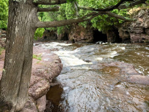
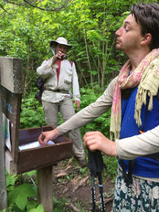
Because of our change in plans, Ed had to reconnoiter with Brian and Bob. So he stayed with them while I hiked on. After finishing the trail through Gooseberry Falls State Park, which was lovely, there was a temporary reroute. The reroute runs along the Gitchee-Gami State Trail for 2.1 miles (3.4 km), then goes up Blueberry Hill Road for a mile before getting back on the real trail.
At the start of the reroute, I ran into two other thru-hikers: BlueBerry and Green Tortuga. Nice guys. We chatted a bit, then went our separate ways. A minute later I was looking at my map and did something – who knows what – and ended up falling down and wrenching the big toe on my right foot. Wonderful.
I gimped down the path and missed the turn onto Blueberry Hill Road, adding another .8 miles (1.3 km) to my day. Then I somehow lost my hat without even realizing it. Luckily some trail runners practicing for Voyageur found it and, as they were doing an out-and-back, delivered it back to me. How sweet!
 Now Entering Split Rock Lighthouse State Park
At that point I had reconnected with BlueBerry and Green Tortuga. I said the hat return was trail magic, but Green Tortuga said that kind of incident is actually called trail mail. Love it!
The trail wound through Split Rock Lighthouse State Park, which was absolutely gorgeous. The path goes up one side of the Split Rock River and down the other. I hung out with Green Tortuga for most of the way, chatting about our hiking adventures and lives.
He has a website, Walking4Fun, which lets you log your steps (if you track them) and then see where your daily mileage would get you on a famous long-distance trail like the AT or PCT. He will add the SHT to the options!
Water Crossing
At one point in the hike, the bridge crossing the river was out. We knew this; it was posted all over. Supposedly the crossing is easy to do on rocks, assuming there hasn’t been a lot of rain. The latest intel said the crossing was fine. Um, no.
When we got there, the bridge was out but there was no obvious spot to cross safely. Everyone was doing their own thing. I’m  not great on crossing rushing rivers, nor hopping on stones that are far apart. BlueBerry – a young man – was able to nimbly hop across. I asked him to wait and make sure I got across walking through the water. Two other women hikers helped direct me as well. I made it across, but I’m not sure if I would have done it if there weren’t others around.
Once on the other side of the river, I saw the campsite we had planned to stay at tonight. It was absolutely lovely. Possibly the best I’ve seen, based on the flat tent pads, easy access to water, lack of mud, etc. Oh well.
Ed hiked in to meet me, and as nice as that campsite was, I almost wept for joy checking into the AmericInn. There is nothing like a shower and comfy bed after four days of hiking through mud, rain, rocks and roots.
Snowshoe
MN NCT miles today: =16 (25.8 km)
MN NCT miles to date: 138.5 (222.9 km)
SHT miles to date: 138.5 (222.9 km)
Total NCT miles to date: 425.1 (684.1 km)
Total NCT miles to go: 4,174.9 (6,718.9 km)
Book your stay at the AmericInn by Wyndham Silver Bay here!


