Today’s destination: Deep Creek Lake State Park. I slept great last night in my wooden aerie. I heard the usual birds and bugs at night, but no mammals or humans or even cars. It was such a quiet night! The temps were nice and cool, too.
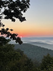
I woke this morning to a glorious sunrise outside my tent, which I thoroughly enjoyed. Since I had no pressing mileage goals nor a daunting itinerary, I took my time and even let the morning sun dry off the dew on my rain fly.
Striking Out for Deep Creek Lake State Park
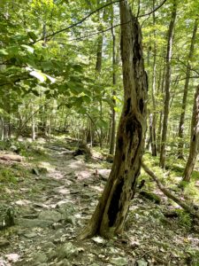
By 8:30 a.m. I was on the trail. To get off Meadow Mountain, you have to backtrack a tiny bit to access this beautiful dirt trail that easily winds down the mountain. It was a lovely start to the day, made better because I was finally able to chat with my son, Tim, and see how he’s been doing.
After finishing the 2.3-mile trail (3.7 km), I faced a road walk of some 6 miles (9.7 km). Actually, I wasn’t sure if I did or not. You see, the 6 miles is the distance to Deep Creek Lake State Park (DCLSP) on the roads. Within the park, there is a stretch of the PHT that is another 6 miles or so.
Disclosure: This post contains affiliate links (among regular links) to products I own and like, or which I think you might like. This means that, at no extra cost to you, I will earn a commission if you click through and make a purchase.
Some maps show that you can access the PHT from the road before entering the park. I hoped that was the case, since then I could hike into the park on the PHT and finish that segment. If not, I’d have a to do an out-and-back from the park.
Alas, there was no easy way to reach the trail from the road. The access roads marked on some maps appeared to be private property, which was not only gated, but not mowed and featured waist-high vegetation. So I hiked to the park.
Tackling DCLSP
I arrived at the park at noon, but couldn’t set up my tent because the staff was still cleaning. Campsite check-in was 3 p.m. Thankfully, the staff agreed to stash my backpack in their office so I could hike around the park with a light day pack.
Not surprisingly, while the park staff knew the PHT ran through the park, they said it wasn’t marked as the PHT. Worse, the NPS app didn’t exactly match up with the park’s trail maps. All I could do was give it my best try.
Suffice it to say, I hiked an out-and-back on what was, I’m fairly sure, the PHT. For the most part. I definitely went off-course a few times, plus there were some oddities. The NPS app, for example, showed the PHT ending in the north in the middle of a marked mountain biking trail. It also showed the PHT taking a right turn where there was no path. So … par for the course.
Setting Up Camp
I’d heard there was a nice shop – Arrowhead Market – a few minutes away. By car, that is. It was a 2.5-mile (4 km) hike from my campsite, or a 5-mile (8.1 km) round trip. But it looked awesome, with a great fresh fruit and veggie section, deli sandwiches and more.
Fortuitously, while I was setting up camp a young man asked me about my hike. He was just napping, then leaving in an hour. He offered to take me to the market and back, as he’d done long-distance hiking and knew how helpful this kind of thing is to a backpacker – and how easy for someone with a truck. So while he napped, I showered and set up my tent. Now, just as I’m writing this, he’s getting ready to take me into town.
I’m looking forward to getting a salad to accompany my pasta tonight, plus some fresh fruit for the morning. And whatever else I see that looks good!
Snowshoe
Today’s Miles: =18.3 (29.5 km)
PHT Miles to Date: 618 (994.6 km)
PHT Miles to Go: =132 (212.4 km)


