Today’s hike was a trek from was French Camp to Ballard Creek. My friend and fellow travel writer, Amy Eckert, would be joining me tonight. Yay! Before I began hiking, I first looked around French Camp. This is one of the more extensive stops on the Natchez Trace.
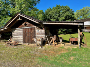
French Camp was a stand (inn) on the Trace, created by Frenchman Louis LeFlore. Locals dubbed it “French Camp” due to Louis’ nationality. LeFlore married a Choctaw woman and they had a son. Their son, who changed his first name to Greenwood, became a famous Choctaw chief and Mississippi state senator. Today, there are old and/or recreated buildings to see, plus Greenwood’s carriage. There’s also a B&B and café here.
After walking around the place, I hiked out a few miles and came back, then drove up to Jeff Busby, a campground and one of Mississippi’s highest spots, at 603 feet (183.8 m). I ran into my Ohio recumbent bicycling friend here. I learned his name – Gary – and met his wife, Louise. They live right on the North Country Trail, and invited me to camp in their yard when I’m passing by. How kind!
Heading Toward Ballard Creek
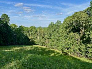
Next up was an out-and-back from Jeff Busby to Ballard Creek. Wish I didn’t have to do these out-and-backs, but as I’ve said before, you don’t have too many options if there’s no one to shuttle you. Anyway, the scenery was pleasant along the way, and I enjoyed seeing all of the wildflowers. Actually, they’ve been great this entire time. Wish I knew their names. Alas, while I love wildflowers, identifying them isn’t a strong interest of mine.
Anyway, while hiking, I pondered where to camp tonight. The Grand Marais biking ladies were staying at Jeff Busby, so I thought of staying there, too. But the campground bathroom was closed, and the campground itself was narrow and cramped.
Next, I thought about camping on a section of the Old Trace that I’d 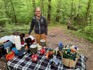 be passing today. That would help me imagine what it was like for the people who used this trail 200 years ago. But when I got there, the ground sloped downhill – not good for tents – and there wasn’t even a picnic table.
At the end of the day, I reached Ballard Creek and got a nice surprise. It was a perfect camping spot! Although not near the creek itself, the site featured a short path from the parking space to a small, open area with a picnic table and plenty of space for two tents. The ground was soft and cushy, with pine needles, and flat – perfect for camping!
Leaving Ballard Creek
I hiked back to Jeff Busby and, before leaving, drove up the winding road to the top, where there was a beautiful overlook. Then it was back to Ballard Creek. As I finished setting up camp and cleaning up, Amy arrived. We had a lovely dinner and talk before heading to bed.
Snowshoe
Natchez Trace Miles Today: 20.6 (33.2 km)
NT Miles Overall: 202.3 (325.6 km)
NT Miles To Go: 241.7 (389 km)
Disclosure: This post contains affiliate links (among regular links) to products I own and like, or which I think you might like. This means that, at no extra cost to you, I will earn a commission if you click through and make a purchase.
A good book on the Natchez Trace is Nashville to New Orleans Road Trip, a Moon guide by Meg Littman that includes info on the Trace.
