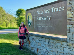
My first-day itinerary called for hiking about 20 miles (32.2 km) from the southern terminus to the end of the Potkopinu section. As I mentioned in yesterday’s post, the Natchez Trace National Scenic Trail consists of 62 miles (99.8 km) of trail along the 444-mile (714.6-km) parkway. The first trail segment is a 3-mile (4.8-km) stretch called Potkopinu, from about mile post 17 to 20.
Ed and I hoped to start around 8 a.m., but it was hard to find the start of the trail. This is ridiculous, since Natchez isn’t a big town. They had signs all over for some other trail, but nothing about the Natchez Trace Parkway. Googling kept putting me on the Trace about 10 miles (16.1 km) out, accessed from a spot north of the terminus. Finally, after asking at a gas station, we found it. So our day started an hour later than planned.
Shuttling to Potkopinu
Often when we have two cars, our shuttling strategy involves dropping one car at our ending point for the day, driving back to our starting point and then heading out. At the end of the day, we drive car #1 back to the start to pick up car #2 and then drive both up the trail to our ending spot for the day.
Because I’d been having back issues for the last month, I wasn’t sure I could hike 20 miles (32.2 km) today. So instead of the above shuttling method, we employed the drive-north-but-hike-south method we’d used for both the New England and North Country Trails, aka leapfrogging. While it’s not as much fun to be moving north, yet hiking south, this method saves substantially on miles driven. In the above 20-mile (32.2-km) scenario, leapfrogging ends up in driving 40 miles (64.4 km) per day for both cars versus 120 miles (193 km) if you keep leapfrogging
Since there are interpretive pullouts every 3-5 miles or so (4.8-8 km) , we ended up hiking for 1-2 hours along the parkway, then driving another car ahead. I think these frequent stops, where I’d shed my backpack and be moving my body in different planes of motion, really helped. I easily hiked the 20 miles (32.2 km) to Potkopinu as planned!
Hiking the Parkway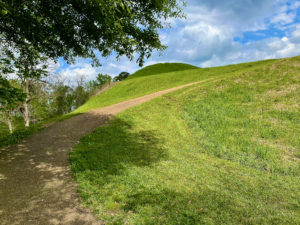
A lot of die-hard long-distance hikers eschew the Natchez Trace because there are so few miles of trail. I get it. It’s not fun hiking along a parkway. Yet this isn’t bad, either. While there’s regular traffic here, it’s a parkway, not a highway. So it’s not that bad. The worst part is that there isn’t a shoulder, and the mowers haven’t mowed the vegetation yet. It looks like the kind of vegetation that could be full of ticks at this time of year, so when cars were coming toward us I didn’t want to move into the grass. Instead, I moved as far over as possible. Everyone seemed fine with that, luckily.
The terrain today was flat-ish to gently undulating. Nothing strenuous. We did take a side road to see Emerald Mound, the tallest Native American burial mound in the U.S., outside of Cahokia, Ill. Impressive!
Arriving at Potkopinu
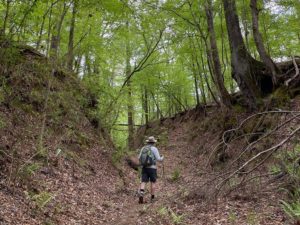
At the end of the day, we hit Potkopinu. This is billed as the longest section of Old Trace that you can hike, at 3 miles (4.8 km). The first two miles (3.2 km) heading southbound were very difficult due to TONS of downed trees, I’m sure from the February ice storm. It was very slow going. But it was so cool to be hiking in the actual old Natchez Trace.
The earth was sunken as much as 20 feet (6.1 m) in places. As we inched our way along the difficult terrain, which featured some quicksand near a creek that snagged Ed’s feet (!), it gave us some sense of what the pioneers faced. I can’t even imagine! They didn’t have our technical clothing or advanced bug sprays or phones with navigational devices. They were some bad-ass people to tackle this.
At one point, about eight feral pigs appeared on the trail ahead of us. I yelled, “Feral hogs!” and they quickly scurried off. Thank goodness, as they’re supposed to be potentially dangerous. Shortly after that, Ed spotted a raccoon climbing a tree.
An Odd Accident at Day’s End
To camp along the Trace, you need a special-use permit. The ranger said you can camp within 200 yards (183 m) of the parkway, and it’s fine to camp at interpretive sites/pullouts if you stay relatively hidden. So tonight we’re camping at Coles Creek, a rest area. The bathrooms are locked (darn), but there are picnic tables here and garbage cans. Score!
As I was setting up the tent, I knelt in the freshly mowed grass – right onto a thick stick. It seemed like no problem, but when I stood up, the stick was stuck in my knee. Again, no problem. I just yanked it out. But the second I did, a huge, thick stream of blood flew out of my knee in an arc. I was really concerned I’d need stitches, but after some pressure and a bandage, it seems fine.
What will tomorrow bring?
Snowshoe
Natchez Trace Miles Today: 20 (32.2 km)
NT Miles Overall: 20 (32.2 km)
NT Miles To Go: 424 (682.4 km)
Disclosure: This post contains affiliate links (among regular links) to products I own and like, or which I think you might like. This means that, at no extra cost to you, I will earn a commission if you click through and make a purchase.
Interested in planning a Trace trip of your own? Check out this book, Traveling the Trace.


