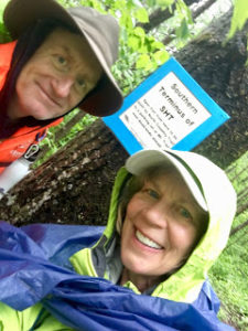
Wow, what a crazy first day on the trail (heading north from the southern terminus). The Superior Hiking Trail (SHT) starts in the south in the middle of the woods on the border with Wisconsin. Since the parking area is two miles away, you have to hike in to the terminus, then hike back out and continue on.
So Ed (Stubs) and I were set to start hiking around 9 or 9:30 a.m. – a bit late, but we were driving up from Eau Claire this morning. The forecast called for highs around 45 F. (7.2 C.) with rain starting around noon. Not the greatest. Well, it began POURING shortly before we were to start. Since this hike is part of a project with the Star Tribune, we had planned to meet Brian Peterson (photographer/videographer) at the trailhead closest to the southern terminus. Brian is going to take pix and video every day, and certainly wanted to capture my start. Anyway, Brian was waiting for us at the trailhead. Due to the rain, the three of us all sat in our cars, waiting for the deluge to stop.
Heading Out from the Southern Terminus
Well, after 20 minutes or so the rain finally slowed a little, allowing Brian to shoot some video. Then, we began. The 3.8-mile 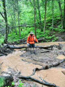 (6.1 km) out-and-back to the official southern terminus marker wasn’t that bad. Thankfully, the rain slowed a little and we saw some beautiful trillium along the trail. We were even able to lunch at a campsite, which enabled us to set our packs on a bench and keep them off the soggy ground.
Disclosure: This post may contain affiliate links (among regular links) to products I own and like, or which I think you might like. This means that, at no extra cost to you, I will earn a commission if you click through and make a purchase.
But the rest of the day was tough. First, the rain never stopped. It just kept changing from a downpour to a drizzle. So we were either walking through puddles or through grass that soaked our feet. (And the wet grass was actually worse than the puddles.) Then, although I was dressed in layers, several rain garments, gloves, etc., I still got waterlogged. Worse, we didn’t want to drink or eat. That’s because it’s a hassle to dig out from under your poncho, backpack cover, etc. to get at things. Also, once you stop hiking, you quickly get colder and wetter. But the problem with this is that if you don’t eat and drink enough, you lose energy.
Hypothermia Dangers
In addition, we were at risk of hypothermia. Actually, I wasn’t at too much of a risk since I dressed properly. But Stubs just had on shorts and a not-so-great raincoat and was quite cold by the time we finished. In fact, as soon as we reached our motel, I made him rush into a hot shower and stay there for a while.

Anyway, despite the nasty weather, I did manage to get a few photos. And in the afternoon, we were treated to the sight of some lovely yellow lady’s slippers. But we are REALLY looking forward to tomorrow, when it should be about 20 degrees warmer and DRY.
By the way, tonight we’re staying at the Best Western (Spirit Mountain) just south of Duluth. It’s great (clean, friendly staff) and the location is perfect for all of the SHT miles around Duluth.
Snowshoe
MN NCT miles today: 16.3 (26.2 km)
MN NCT miles to date: 16.3 (26.2 km)
SHT miles to date: 16.3 (26.2 km)
Total NCT miles to date: 286.6 (461.2 km)
Total NCT miles to go: 4,313.4 (6,941.7 km)
Book a room at the Best Western Plus Spirit Mountain here!
